Background
Disturbances are large-scale episodic events that create abrupt changes in community structure, regulate ecological processes in ecosystems, and generate biological legacies that interact with environmental conditions thus defining trajectories of ecosystem recovery. In neotropical northern latitudes such as south Florida, hurricanes are recurring high-energy disturbances in coastal regions that significantly change community structure and function of mangrove wetlands. Hurricane force winds change forest structure through defoliation, tree snapping, and uprooting, which in turn influence tree mortality, species composition, successional patterns, nutrient cycling, and potential loss in soil elevation. Despite the destructive impacts of hurricanes, these highly productive forested wetlands are well-adapted to recover quickly from disturbance due to their adaptations and intrinsic resilient traits. Further, storms can also deliver phosphorus (P) rich mineral sediments that build elevation and provide nutrients that fertilize soils, promoting vegetation regrowth and fast recovery post-disturbance.
Hurricane Irma made landfall as a Category 3 storm on the southwest Florida coast near Marco Island on September 10, 2017. The storm surge produced maximum water levels up to 3 m above ground level along the southwest coast of Florida. Irma’s winds resulted in large-scale physical damage to mangrove forest structure (i.e., defoliation, tree snapping and uprooting), while the storm surge deposited a thick layer (up to 6 cm) of allochthonous mineral sediment rich in P across the Florida Coastal Everglades (FCE) (Castañeda-Moya et al. 2020). Indeed, this landscape mineral deposition and damage to mangrove forest structure was similar to that caused by Hurricane Wilma after its passage across the FCE in 2005 (Castañeda-Moya et al. 2010; Rivera-Monroy et al. 2019). These sediments, rich in P relative to the Everglades interior, facilitated rapid recovery of the forest post-Wilma within a short period (<5 years; Danielson et al. 2017). This demonstrates high adaptive capacity and resilience of mangrove species that confers stability to an extensive region impacted by recurrent large-scale disturbances in the long-term. Our proposed after-impact research project is needed not only to evaluate immediate impacts as a baseline for potential post-hurricane trajectories of recovery, but also to assess species-specific responses and trajectories of mangrove recovery since this area of south Florida has not experienced any significant tropical cyclone activity since Hurricane Wilma in 2005. This research will provide fundamentally important information about the state and potential future of Everglades National Park natural resources.
Research Objectives
Our proposed research will test the extent and duration of hurricane impacts on species-specific responses, community and ecosystem trajectories, and resilience capacity (i.e., recovery duration and rate) in mangrove forests across the Everglades landscape.
As part of the Florida Coastal Everglades Long-Term Ecological Research (FCE LTER) program (http://fcelter.fiu.edu/), we initiated a comprehensive research campaign (NSF RAPID) and partnered with an airborne data collection (NASA – RRNES) in January 2018 to document the immediate impacts of Hurricane Irma on mangrove structural attributes and test a set of hypotheses to validate conceptual and computational models of how hurricane impacts and interactions among disturbance legacies (i.e., hurricanes, cold snaps) influence resilience of mangrove forests. With this project, we build upon this research and propose new satellite sites with permanent plots to improve our understanding on trajectories of mangrove recovery post-hurricane disturbance across the FCE landscape.
Study Area
This study is conducted in mangrove forests of Everglades National Park (ENP), south Florida. This area is part of the FCE-LTER program. Mangrove forests in southwestern FCE form a continuous band of riverine mangroves that extends along a freshwater-estuarine gradient, from the lower reaches of freshwater marshes in Shark River Slough to the Gulf of Mexico, a distance of about 15-20 km that sets the limits of periodic saltwater and tidal influence. Mangrove wetlands in southwestern FCE encompass mixed-species stands of Rhizophora mangle, Avicennia germinans, Laguncularia racemosa, and Conocarpus erectus; the latter species is restricted to upstream locations of the estuary where salinity does not exceed 10 ppt.
Mangrove sites are located along the Shark, Harney, and Broad Rivers in southwestern FCE. The Shark River sites (SRS-4, SRS-5, and SRS-6) are part of the FCE-LTER program. The SRS-6 site is located 4.1 km from the mouth of the estuary, while SRS-5 and SRS-4 are 9.9 and 18.2 km from the river mouth, respectively. Mangrove sites along Harney River are located approximately 10 km (WSC-8), 6 km (WSC-9), and 2 km (WSC-10) from the mouth of the estuary. In Broad River, sites are established at 7 km (WSC-12) and 3 km (WSC-13) from the river mouth.
Mangrove areas in southwestern FCE have a semi-diurnal tidal exchange (mean amplitude is 1.1 m). The south Florida’s climate is subtropical savanna with a typical dry season from December to May, and a wet season from June to November. For more information about the study sites and recent publications about the project, please refer to publications by Castañeda-Moya et al. 2013, 2020.
Project Collaborators
Tiffany Troxler, John Kominoski, David Lagomasino, Jay Sah
Funding sources
Department of the Interior – National Park Service
Contact Edward Castaneda (ecastane@fiu.edu) for more information about the project.
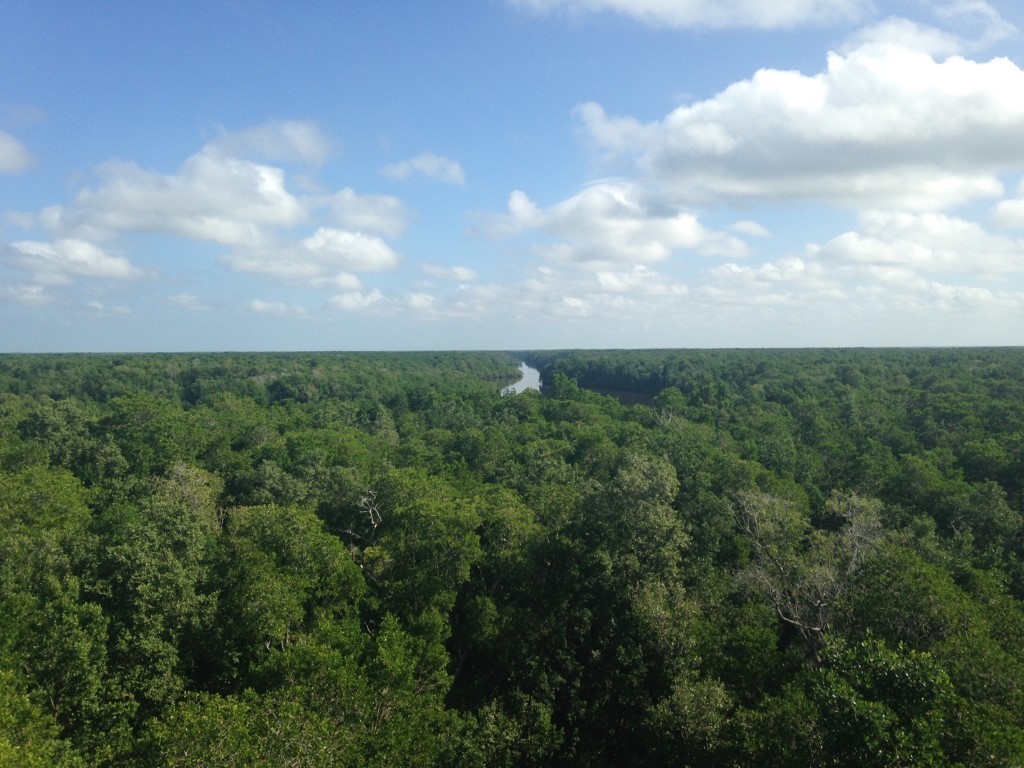
Figure 1. Panoramic view of riverine mangrove forests at SRS-6 downstream of Shark River estuary. Photo taken from the top (30 m) of the eddy flux tower.
A)
B)
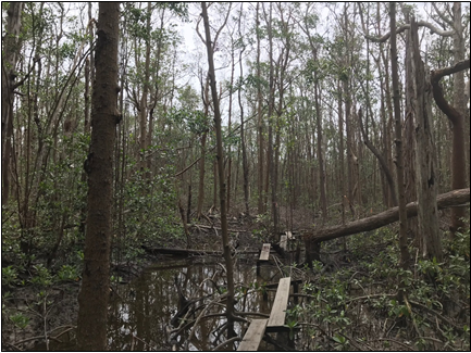
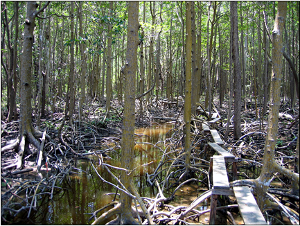
Figure 2. Mangrove forest at SRS-6 before (A) and after (B) the passage of Hurricane Irma across the Everglades on September 10, 2017. Irma created significant damage (i.e., defoliation, tree snapping and uprooting) to near-coast mangrove areas in southwestern FCE.
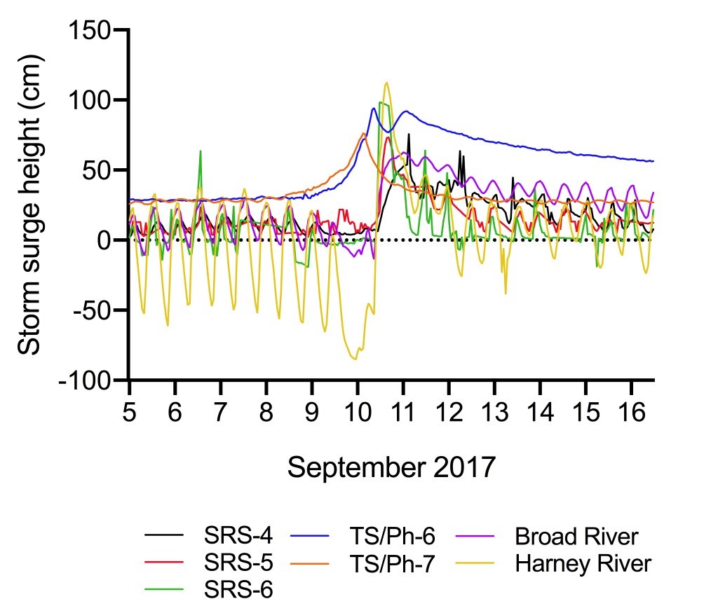
Figure 3. Changes in water levels associated with Hurricane Irma’s storm surge measured at FCE-LTER mangrove sites (SRS-4, SRS-5, SRS-6, TS/Ph-6, TS/Ph-7) and at permanent gauges located in the main channel of Broad and Harney Rivers. The zero mark for mangrove sites is relative to the soil surface and data are not referenced to the North American Vertical Datum of 1988 (NAVD88) (Castañeda-Moya et al. 2020).
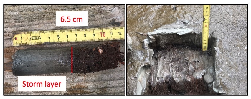
Figure 4. Storm-derived inorganic sediment deposited on mangrove peat soils (dark brown) across mangrove forests in the FCE after Hurricane Irma. Storm deposition extended up to 10 km upstream of estuaries in southwestern FCE.
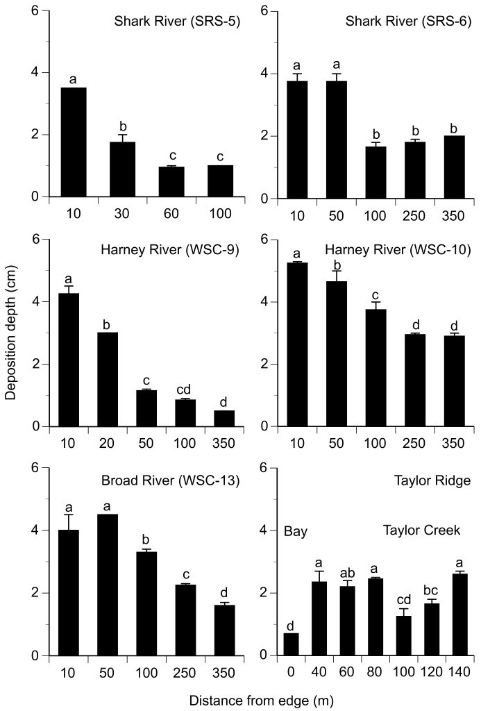
Figure 5. Depth of storm-derived deposits at mangrove sites in the FCE after the passage of Hurricane Irma. Different letters indicate significant differences (P < 0.05) among sampling points along each transect site. Distance from edge refers to the line transect established from the mangrove fringe adjacent to the main channel to the forest interior (Castañeda-Moya et al. 2020).
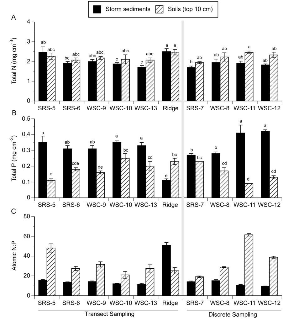
Figure 6. Nutrient concentrations in storm sediments and surface soils (top 10 cm) measured at transect and discrete mangrove sites in the FCE after the passage of Hurricane Irma. (A) Total nitrogen. (B) Total phosphorus. (C) Atomic N:P ratio. Means (± 1 SE) with different letters are significantly different (Tukey HSD post hoc test: P < 0.05) across sites and layers for each sampling technique (transect sites vs. discrete sites) (Castañeda-Moya et al. 2020).
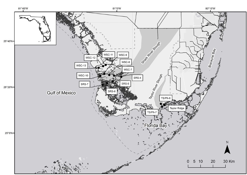
Figure 7. Location of the study mangrove sites in the FCE, Everglades National Park (ENP) in south Florida, USA. SRS-4, SRS-5, SRS-6 are located along Shark River estuary; WSC-7, WSC-8, WSC-9, and WSC-10 along Harney River estuary; WSC-11, WSC-12, and WSC-13 along Broad River estuary; TS/Ph 6 & 7 along Taylor River, and Taylor Ridge located ~1 km east from the mouth of Taylor River. The insert shows the location of ENP in southern Florida, USA.