

Blue Road Tidal Gauge
Background
Coastal wetlands provide essential direct livelihood services to millions of people, as well as critical regulating services such as maintenance of water quality, protection from storms and erosion, and carbon sequestration. Measuring the vertical movement of the coastal wetland surface and its constituent processes, and relative local sea-level rise (SLR) is necessary to determine whether a wetland can keep pace with SLR.
Tidal data can assist in understanding localized flooding associated with king tide flooding and sea-level rise. These data are an important resource for hurricane preparations and for recreational use about boat clearance through rivers and canals.
Study Area
Four monitoring stations are being established: 2 tidal stations at Blue Road and Isla Dorada Boulevard bridges and 2 tidal and soil elevation monitoring sites in Matheson Hammock and a mangrove site near Coral Gables Marina.
Data Access
If you would like to access tidal station data for the Blue Road and Isla Dorada Boulevard bridges to find out what the clearance is under these bridges, please see real-time data link below.
<<CLICK HERE TO LINK TO DATA>>
How to Interpret These Data
When the data is viewed through the HydroVu platform the “Depth” parameter will be used in calculating the Boat Clearance and Water Depth.
For Blue Road East Bridge, Boat Clearance = (5.65 meters – “Depth” meters). To check the tidal water level, go to the link above, select “Blue Road 2.0” under “Locations” on right panel and select “Depth” in options on the top panel. To calculate “Water Depth” use the equation Water Depth = (0.65 meters + “Depth”).
For Isla Dorada Boulevard Bridge, Boat Clearance = (7.45 meters – “Depth” meters). To check the tidal water level, go to the link above, select “Islands of Cocoplum 2.0” under “Locations” on the right panel and select “Depth” in options on the top panel. To calculate “Water Depth” use the equation Water Depth = (1.1 meters + “Depth”).
For example, tidal depth at Blue Road on October 16, 2019 at 10:08 a.m. was 1.74 meters. To calculate distance between the bottom of the bridge (relative height) and the tidal water surface below the bridge relative height, compute: (5.65 meters – 1.74 meters) = 3.91 meters. The result of 3.91 meters can then be converted to feet by multiplying (3.91 x 3.28) = 12.82ft. In this example, 12.82ft is the Boat Clearance or the distance between the bottom of the bridge and the tidal water surface.
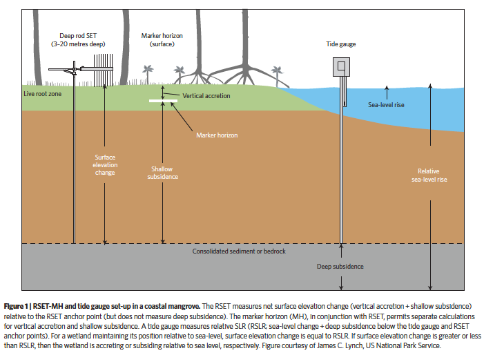
Soil elevation and tidal gauge set-up in a coastal mangrove (Figure courtesy of J.C. Lynch, U.S. N.P.S.)